
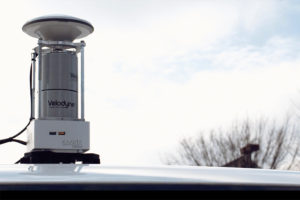
Real-time mobile 3D reality capture and mapping technology firm Kaarta has included smart and powerful laser scanning equipment from Velodyne Lidar Inc. in its new Stencil 2-32 ground surface mapping system for infrastructure and asset management.
 Kaarta’s patent-pending technology, rooted in advanced robotics, accurately transforms the real world into 3D digital twins, streamlining workflow, reducing time, lowering cost, and providing a new level of understanding of spaces for humans and autonomous machines alike. Equipped with Velodyne lidar, Kaarta’s Stencil 2-32 system accurately scans ground level surfaces, mapping items such as curbs, sidewalks, potholes, manholes, signs, poles, and other roadside features at a fraction of the cost of traditional mobile mapping systems. The Stencil platform helps enable city planning for infrastructure improvements, as well as parking and traffic management. The 3D data generated by Stencil 2-32 can be used for a range of applications, including highway assessments, BIM modeling, geospatial data analytics, and cataloging tools.
‘) } // –>
‘) } else { console.log (‘nompuad’); document.write(‘
‘) } // –>
The Stencil platform integrates 3D mapping and real-time position estimation to create capabilities not possible with fixed-base scanning systems. Stencil 2-32 incorporates the Velodyne HDL-32E lidar sensor, which provides a range of 328 feet (100m) and a data rate of 720,000 points per second. Kaarta makes use of advanced robotics technology that combines input from multiple sensors, including lidar, visual odometry, and inertial measurement unit (IMU), and processes that data in real-time. For some applications, the data can be enhanced with Global Navigation Satellite System (GNSS) positioning and wheel odometry sensors.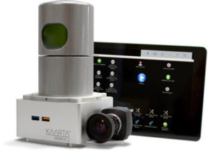
The 2-32 unit is the newest member of Kaarta’s Stencil product line, which also includes Stencil 2-16, a versatile low-cost mobile mapping platform that uses the Velodyne Puck lidar sensor. Its ease of use, breadth of applications, and streamlined workflow make the system well-suited for infrastructure inspectors, surveyors, engineers, architects, facilities planners, security personnel, and more. One of the early users of the system is developer of street-level analytics software, Allvision, which uses Stencil 2-32 along with data from an autonomous vehicle developer to conduct curb occupancy analysis in Pittsburgh’s Strip District, an area known for high on-street parking demands. Allvision’s new Parkview system allows city planners to monitor parking behavior to improve transportation planning and curb management.
“Velodyne lidar and Kaarta’s advanced 3D mapping and localization algorithms are a phenomenal combination, creating a portable system for fast and easy detailed surface mapping,” said, Allvision’s founder and CEO, Aaron Morris. “The ability to rapidly gather accurate and up-to-date geospatial information has countless applications.”
Kaarta’s CEO, Kevin Dowling, said, “The addition of Stencil 2-32 to our product line further extends the range of mapping applications for mobile lidar scanning. The low noise, long range, and field of view of Velodyne’s compact lidar sensors allow us to create systems with immense versatility, accuracy, and speed; from capture to answer.”
Mike Jellen, president and CCO at Velodyne, said, “Kaarta and Allvision demonstrate how to tap the full potential of our rich computer perception data for an innovative solution to inventory, track, and monitor assets for accurate future planning and management.”